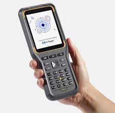
For generations, the field surveyor has been defined by their tools. Rugged, dedicated, and often prohibitively expensive, these devices were masters of one task but prisoners of their own ecosystems. They created a world of locked workflows, proprietary software, and a high barrier to entry. Today, a quiet but profound revolution is unfolding in the field data collection industry, driven by three interconnected trends: the shift to open Android platforms, the relentless push for high integration, and the transformative move towards democratisation. At the heart of this shift is the Hi-Target iHand 20, a handheld data controller that embodies this new philosophy, not by adding complexity, but by offering liberating simplicity for surveying and GIS professionals.
This evolution mirrors a broader marketing shift from broad-brush approaches to precision targeting and personalised value. Just as modern marketers use data to deliver the right message at the right time, modern field tools must deliver the right functionality at the precise point of need. The Hi-Target iHand 20 represents this principle in hardware and software, moving away from the “one-size-fits-all” mentality to a versatile, user-centric platform.
Embracing the Open World: The Android Advantage
The most significant break from tradition is the adoption of the ubiquitous Android operating system. Moving from a closed, proprietary environment to an open platform like Android is a game-changer for field workflow flexibility. The Hi-Target iHand 20, running on Android, liberates data collection from the constraints of pre-installed, single-purpose software.
Imagine a utility surveyor conducting a pipeline in an urban environment. With a traditional controller, their workflow might be linear and limited. With the Hi-Target iHand 20, the same surveyor can seamlessly switch between a dedicated GNSS data collection app, a notes application for logging observations, a mapping service for real-time orientation, and the device’s own camera to capture geotagged visual evidence of assets or issues. This interconnected capability turns the controller from a simple data logger into a comprehensive field computer. The ability to side-load specialised apps or use cloud-based collaboration tools means teams are no longer siloed by their equipment’s limitations, fostering better communication and data consistency from field to office.
The Unified Hub: Mastering High-Integration Workflows
The second trend addresses the perennial field challenge of device sprawl and workflow fragmentation. Modern surveying projects often require a symphony of instruments—GNSS receivers for broad positioning, total stations for precise detail, and perhaps data from drones or laser scanners. The Hi-Target iHand 20 is engineered to be the conductor of this orchestra.
Consider a complex topographic survey for a renewable energy site in the British countryside. The terrain varies from open fields to wooded areas. A surveyor using the Hi-Target iHand 20 can start the day using it as a high-precision RTK controller for open-area mapping. When reaching a tree-lined boundary, they can effortlessly switch to controlling a robotic total station via Bluetooth, all without changing hardware or disrupting the project file. This deep high integration eliminates the need for multiple dedicated controllers, reduces setup time, and crucially, ensures all data streams into one unified project. This seamless flow is vital for efficiency, minimising errors and saving hours in post-processing.
Democratising Precision: Power in Every Hand
Perhaps the most impactful trend is the democratisation of professional-grade technology. Historically, the cost of “industry-standard” equipment could be a barrier for smaller consultancies, independent surveyors, or allied professions in construction, archaeology, and agriculture. The Hi-Target iHand 20, by leveraging open-source Android and scalable hardware design, delivers robust capability at a more accessible point.
This accessibility empowers a new tier of professionals. A civil engineering contractor can now equip site supervisors with a tool for rapid as-built verification and volume calculations. An archaeological team can afford multiple units for a large dig site, using the intuitive interface to record finds with precise coordinates and rich media. This democratisation broadens the market and raises the standard of data-driven decision-making across industries, allowing more businesses to benefit from precise geospatial information.
Engineered for the Real World: Beyond the Trends
While the trends define its position, the Hi-Target iHand 20 is built for the harsh realities of field work. Its rugged design, meeting IP67 standards for water and dust resistance, is essential for reliability in the unpredictable British climate. A long-lasting battery ensures it survives a full day on a remote site. The responsive touchscreen remains usable in damp conditions or with gloves.
For the UK market specifically, considerations around data privacy and secure handling of geospatial information are paramount. The Android platform allows for the implementation of robust security protocols and encrypted data workflows, giving project managers and clients peace of mind.
The Future is Open, Integrated, and Accessible
The Hi-Target iHand 20 is more than just another piece of field hardware. It is a tangible manifestation of a fundamental shift in surveying technology. It champions the Android flexibility that users enjoy in their personal lives, delivers the high integration necessary for complex professional workflows, and enables the democratisation that fosters innovation across sectors.
For the modern surveyor, GIS analyst, or field engineer, this means freedom: the freedom to choose the best apps, the freedom to connect the best instruments, and the freedom to bring high-precision data collection within reach of any project. The future of field data isn’t about more specialised tools; it’s about more intelligent, open, and empowered platforms. The future fits in the palm of your hand.